It’s time to answer one of the big questions. When and Where are you going to launch this thing?
The short answer is: I don’t know yet and I wont know until 12-18 hours before launch.
High Altitude Ballooning is a bit unpredictable and we are completely subject to wind direction and strength through multiple dynamic wind layers at all altitudes while ascending and descending.
The first consideration is simple. I need to find a weekend in the next 15-60 days that I can launch and recover without obligations to my 3 year old son. I also have some Saturday work obligations to Baylor University home football games (American football for those followers in the UK).
I’m not restricted to Saturdays, but my intent has always been to launch early on a Saturday to give us 36 hours to recover the payload if we are covering long distances or if we have to find the owner of a property and get permission to enter. There could also be complications like getting stuck in trees or floating in a pond/tank* somewhere that I’d like to have a Sunday to work with. I will launch on a Sunday if it makes sense. I will identify potential launch dates on the next update.
*I realize that some non-Texas project backers may not have a clue that we call small bodies of water ‘tanks’.
Launch location will be determined ‘generally’ 12-18 hours beforehand by looking at winds-aloft forcasts from the surface up through 60,000′ feet. Forecasting above 60k feet is rare (airliners don’t fly that high) and winds generally die down above the ‘jet stream’.
Winds in Central Texas ‘trend’ from the south and west. Often this time of year though, we get strong winds coming in from the north.
Surface winds are a consideration because inflating a very fragile balloon in winds greater than 10kts can be futile. Wasting a balloon and expensive helium just to force a launch at a specific time is irresponsible to everyone involved.
Surface winds DO NOT reflect what’s going on above us in the atmosphere. Things like trees and buildings and hills can funnel wind around the surface in weird ways. There are also conditions where winds are doing completely contradictory things in as few as 50 feet off the ground.
One ‘could’ do the math on all these different vectors that a balloon would be subject to through 10-15 prescribed levels of altitude. An important factor to consider is the balloon’s rate of ascent through these layers. For example, a balloon might rise at 500ft per minute and spend 10 minutes climbing through each ‘zone’ or if you have a bigger balloon and a lighter payload, you might climb at 1,200 feet per minute spending only 4 minutes being pushed a given direction at a certain speed. For example, the first quarter of the ascent might look like this:
(I’m using general directions instead of actual wind headings)
00000-05000ft North 12kts
05000-10000ft Northwest 22kts
10000-15000ft Northwest 40kts
15000-20000ft West 55kts
20000-25000ft South 40kts
OR
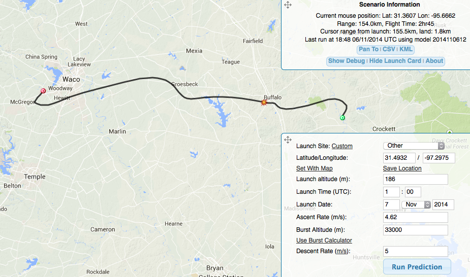
Better yet, we use a high-altitude ballooning prediction tool. I’ve included some links and screenshot of what a predicted balloon path would look like if I launched at 7a tomorrow morning from an elementary school parking lot not far from my house. Notice the first few minutes and the last few minutes of the flight, the balloon is tracking mostly to the south and then abruptly toward the east. Once it climbs 10-15k feet the predicted path starts heading east in a HURRY. Tomorrow would be a ‘less than ideal’ launch day.
The flight reflected below is calculated on a FAST rate of ascent with a bigger than average balloon (expensive balloon and more expense for helium to inflate it). This profile is about 2 hours climb and :45 minute descent and it predicts a landing 90 miles east and too close to the piny-woods of east Texas to suit me. If we have a heavy payload or use a smaller balloon, we could be 150 miles downrange and our payload would be subjected to another hour of sub-freezing temperatures.
http://predict.habhub.org/
example: http://predict.habhub.org/#!/uuid=a93aede37dc2bb78de763de253043632591e9642
What is ideal?
Ideal would be a ‘gentle’ wind from the southeast that would facilitate a landing in the zone I’ve identified here:
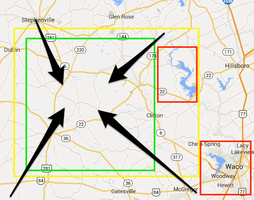
The area northwest of Waco, TX is the best balance of open fields and more accessible property, good visibility of GPS satellite coverage, no large centers of population, no large bodies of water, and no major airports or large military installations. Movement to the south puts me over [or worse, in] the restricted Fort Hood area; too far north and we are close to Dallas/Ft Worth. As long as we are west of Lake Waco and Lake Whitney and north of Ft Hood, we should be in good shape.
I am willing to get up VERY early and travel 90-120 miles to the west and north of home if we can place ourselves in a better to position to launch for recovery in the zones I’ve identified below.

Hey,Josh. Are you coordinating with the FAA on proposed launch/recovery and probable flight path?
LikeLiked by 1 person
Yeah. There will be a NOTAM issued. Running through the regs now.
Local approach/departure guy makes beer and we’ll discuss forms while bottling.
LikeLike